
“Quantifying Uncertainty and Bridging the Scaling Gap in the Retrieval of Leaf Area Index by Coupling Sentinel-2 and UAV Observations” on Remote Sensing journal


Quantifying Uncertainty and Bridging the Scaling Gap in the Retrieval of Leaf Area Index by Coupling Sentinel-2 and UAV Observations

Even within managed crop systems, there is considerable and important within-field variation in LAI at scales finer than the resolution of current satellite imagers.
In this scientific research it is demonstrated that UAV multispectral observations at the cm scale, acquired from a sensor designed to match Sentinel-2 spectral bands, improve interpretation of the satellite signal.
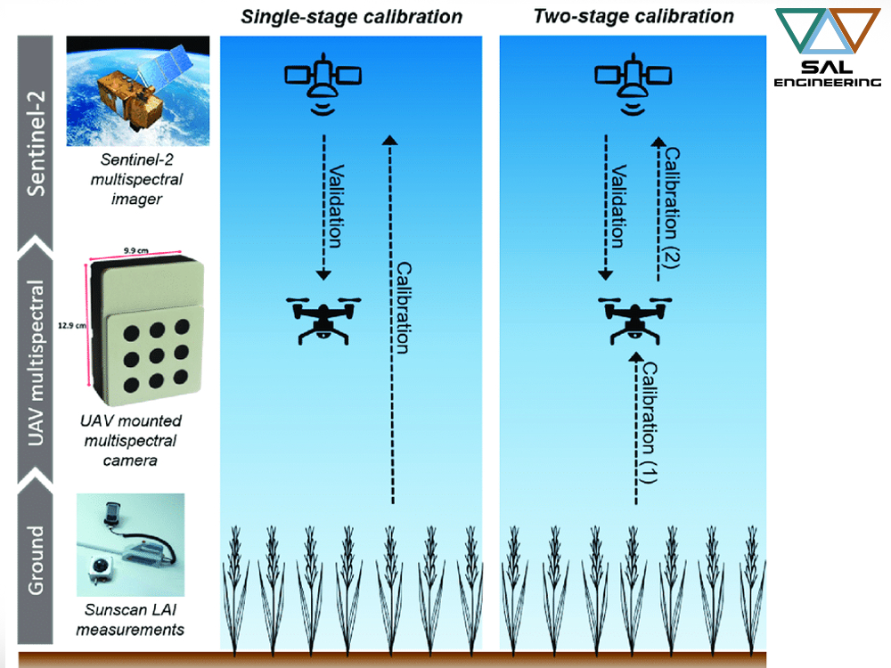
Furthermore, the fine-scale resolution of the UAV sensor provides a tool for accurately upscaling LAI ground measurements, which were collected in coordination with the UAV flights, to satellite resolution. The within-field variance in spectral data resolved from the UAV observations was linked to wheat growth stage. Consequently, the Sentinel-2 and UAV platform data were more comparable at the later growth stages, when the vegetation canopy appeared more homogeneous due to a reduced influence of bare soil.
Calibrating models used to retrieve LAI from Sentinel-2 observations directly from ground measurements performed poorly and were unable to explain the variance in LAI throughout the growing season. On the other hand, our novel two-stage model calibration, involving the use of upscaled UAV LAI estimates, demonstrated a clear improvement in the accuracy of LAI retrievals from Sentinel-2 data, reducing bias strongly.
This study has highlighted the value of UAV observations for eectively providing a link between point measurements on the ground and 20-m resolution multispectral observations made from the Sentinel-2 satellite.
Click here below to read the article:
“The Value of Sentinel-2 Spectral Bands for the Assessment of Winter Wheat Growth and Development” on Remote Sensing journal


The Value of Sentinel-2 Spectral Bands for the Assessment of Winter Wheat Growth and Development

We are proud to share the scientific publication of some researchers who have chosen our multispectral data acquisition system since the initial days when we were in the design and development phase. Below you will find the abstract and the link to access the scientific journal.

Leaf Area Index (LAI) and chlorophyll content are strongly related to plant development and productivity. Spatial and temporal estimates of these variables are essential for efficient and precise crop management. The availability of open-access data from the European Space Agency’s (ESA) Sentinel-2 satellite—delivering global coverage with an average 5-day revisit frequency at a spatial resolution of up to 10 metres—could provide estimates of these variables at unprecedented (i.e., sub-field) resolution. Using synthetic data, past research has demonstrated the potential of Sentinel-2 for estimating crop variables. Nonetheless, research involving a robust analysis of the Sentinel-2 bands for supporting agricultural applications is limited. In this scientific contribution, it is evaluated the potential of Sentinel-2 data for retrieving winter wheat LAI, leaf chlorophyll content (LCC) and canopy chlorophyll content (CCC). In coordination with destructive and non-destructive ground measurements, the team acquired multispectral data from an Unmanned Aerial Vehicle (UAV)-mounted sensor measuring key Sentinel-2 spectral bands (443 to 865 nm). They applied Gaussian processes regression (GPR) machine learning to determine the most informative Sentinel-2 bands for retrieving each of the variables. They further evaluated the GPR model performance when propagating observation uncertainty. When applying the best-performing GPR models without propagating uncertainty, the retrievals had a high agreement with ground measurements—the mean R2 and normalised root-mean-square error (NRMSE) were 0.89 and 8.8%, respectively. When propagating uncertainty, the mean R2 and NRMSE were 0.82 and 11.9%, respectively. When accounting for measurement uncertainty in the estimation of LAI and CCC, the number of most informative Sentinel-2 bands was reduced from four to only two—the red-edge (705 nm) and near-infrared (865 nm) bands.

This research demonstrates the value of the Sentinel-2 spectral characteristics for retrieving critical variables that can support more sustainable crop management practices.

Click here below to read and download the scientific article:


The Value of Sentinel-2 Spectral Bands for the Assessment of Winter Wheat Growth and Development

Andrew Revill 1 Anna Florence 2 Alasdair MacArthur 1Stephen P. Hoad 2  Robert M. Rees 2 and Mathew Williams 1
1
School of GeoSciences and National Centre for Earth Observation, University of Edinburgh
2
Crop & Soils Systems, Scotland’s Rural College, Edinburgh