
MAIA S2 and Sentinel-2: remote to proximal sensing
Comparing multispectral data for environmental monitoring and precision agriculture
Following the development of MAIA WV, the most technologically advanced multispectral camera ever proposed in the market of sensors for surveying by plane or UAV, SAL Engineering has developed MAIA S2, in collaboration with the most important universities and research institutes in Europe, involved in studies of earth observation and remote sensing. MAIA WV has the same wavelenght intervals of WorldView-2 satellite mission by DigitalGlobe: this choice was made following evaluations regarding the most widespread applications of satellite remote sensing that could be useful also in the field of proximal sensing with airplanes or UAVs. In fact, WorldView-2 provides commercially available imagery of 0.46 m resolution, and eight-band multispectral imagery with 1.84 m resolution.

Great interest in the use of satellite images for applications in agriculture and environmental monitoring was given by the Copernicus Programme of the European Space Agency, thanks to the Sentinel missions. The request of large agronomic companies and research institutes involved in sustainable agriculture projects was to have multispectral images at the same wavelength ranges available in the Sentinel missions data hubs, with the same radiometric reliability, but with a much higher geometric resolution and with the possibility to decide the moment of the multispectral survey according to the needs of the agronomic research.
Hence, MAIA S2 is designed to ensure multi-layer and multi-channel images at the same wavelength intervals as the multispectral sensor on board the Sentinel-2 satellite, with complete control on reflectance data and radiometric correction of RAW images, with the advantage of having a ground sample distance lower than 5 cm flying at 100 m AGL.
Sentinel-2 is an Earth observation mission from the Copernicus Programme that systematically acquires optical imagery at high spatial resolution (10m to 60m) over land and coastal waters. The mission is a constellation with two twin satellites (Sentinel-2A and Sentinel-2B). The mission supports a broad range of services and applications such as agricultural monitoring, emergencies management, land cover classification, water quality, disaster control, humanitarian relief operations, risk mapping and security concerns.
The Sentinel-2 mission has the following key characteristics:
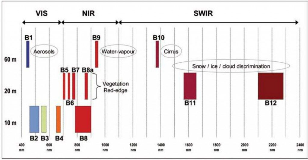
- Multi-spectral data with 13 bands in the visible, near infrared, and short wave infrared part of the spectrum
- Systematic global coverage of land surfaces from 56° S to 84° N, coastal waters, and all of the Mediterranean Sea
- Revisiting every 5 days under the same viewing angles. At high latitudes, Sentinel-2 swath overlap and some regions will be observed twice or more every 5 days, but with different viewing angles.
- Spatial resolution of 10 m, 20 m and 60 m
- 290 km field of view
- Free and open data policy
To achieve frequent revisits and high mission availability, two identical Sentinel-2 satellites (Sentinel-2A and Sentinel-2B) operate together. The planned orbit is Sun synchronous at 786 km (488 mi) altitude, 14.3 revolutions per day, with a 10:30 a.m. descending node. This local time was selected as a compromise between minimizing cloud cover and ensuring suitable Sun illumination. It is close to the Landsat local time and matches SPOT‘s, allowing the combination of Sentinel-2 data with historical images to build long-term time series.
The Copernicus Land Monitoring service became operational in 2012. The object of the service is to provide land cover information to users working in the field of environmental and other terrestrial applications. The service is designed to provide geographical information on land cover and related variables such as the vegetation state or the water cycle, and also supports applications in other domains including spatial planning, forest management, water management, agriculture and food security.
The Copernicus Sentinel-2 mission comprises a constellation of two polar-orbiting satellites placed in the same sun-synchronous orbit, phased at 180° to each other. It aims at monitoring variability in land surface conditions, and its wide swath width (290 km) and high revisit time (10 days at the equator with one satellite, and 5 days with 2 satellites under cloud-free conditions which results in 2-3 days at mid-latitudes) will support monitoring of Earth’s surface changes. The coverage limits are from between latitudes 56° south and 84° north. For mission planning and updated coverage status information, see the Revisit and Coverage page.
Sentinel-2 is a European wide-swath, high-resolution, multi-spectral imaging mission. The full mission specification of the twin satellites flying in the same orbit but phased at 180°, is designed to give a high revisit frequency of 5 days at the Equator. Sentinel-2 carries an optical instrument payload that samples 13 spectral bands: four bands at 10 m, six bands at 20 m and three bands at 60 m spatial resolution.
With its frequent and systematic coverage, Sentinel-2 will make a significant contribution to land monitoring services by providing input data for both land cover and land cover change mapping, and support the assessment of biogeophysical parameters such as Leaf Area Index (LAI), Leaf Chlorophyll Content (LCC) and Leaf Cover (LC).
The high revisit frequency of the Sentinel-2 mission will support the attempts to mitigate deforestation by providing greater opportunities to acquire cloud-free image data. This will be of particular benefit in the tropical latitudes, where heavy cloud cover has previously delayed the potential acquisition of a complete catalogue of data. As well as the same parameters that are used in other GMES/Copernicus programmes (such as FAPAR, LAI, LC, LCC and NDVI) that contribute to the monitoring and modelling of climate-induced changes, high-resolution data from Sentinel-2 can support the change detection of flood events for affected countries. The Sentinel-2 satellites will each carry a single multi-spectral instrument (MSI) with 13 spectral channels in the visible/near infrared (VNIR) and short wave infrared spectral range (SWIR).
Spectral bands for the Sentinel-2 sensors |
||||||
| Sentinel-2 bands | Sentinel-2A | Sentinel-2B | ||||
| Central wavelength (nm) | Bandwidth (nm) | Central wavelength (nm) | Bandwidth (nm) | Spatial resolution (m) | ||
| Band 1 – Coastal aerosol | 442.7 | 21 | 442.2 | 21 | 60 | |
| Band 2 – Blue | 492.4 | 66 | 492.1 | 66 | 10 | |
| Band 3 – Green | 559.8 | 36 | 559.0 | 36 | 10 | |
| Band 4 – Red | 664.6 | 31 | 664.9 | 31 | 10 | |
| Band 5 – Vegetation red edge | 704.1 | 15 | 703.8 | 16 | 20 | |
| Band 6 – Vegetation red edge | 740.5 | 15 | 739.1 | 15 | 20 | |
| Band 7 – Vegetation red edge | 782.8 | 20 | 779.7 | 20 | 20 | |
| Band 8 – NIR | 832.8 | 106 | 832.9 | 106 | 10 | |
| Band 8A – Narrow NIR | 864.7 | 21 | 864.0 | 22 | 20 | |
| Band 9 – Water vapour | 945.1 | 20 | 943.2 | 21 | 60 | |
| Band 10 – SWIR – Cirrus | 1373.5 | 31 | 1376.9 | 30 | 60 | |
| Band 11 – SWIR | 1613.7 | 91 | 1610.4 | 94 | 20 | |
| Band 12 – SWIR | 2202.4 | 175 | 2185.7 | 185 | 20 | |
Due to the layout of the focal plane, spectral bands within the MSI instrument observe the surface at different times and vary between band pairs. The mission will provide information for agricultural and forestry practices and for helping manage food security. Satellite images will be used to determine various plant indices such as leaf area chlorophyll and water content indexes. This is particularly important for effective yield prediction and applications related to Earth’s vegetation.
As well as monitoring plant growth, Sentinel-2 can be used to map changes in land cover and to monitor the world’s forests. It will also provide information on pollution in lakes and coastal waters. Images of floods, volcanic eruptions and landslides contribute to disaster mapping and help humanitarian relief efforts. Examples for applications include:
- Monitoring land cover change for environmental monitoring
- Agricultural applications, such as crop monitoring and management to help food security
- Detailed vegetation and forest monitoring and parameter generation (e.g. leaf area index, chlorophyll concentration, carbon mass estimations)
- Observation of coastal zones (marine environmental monitoring, coastal zone mapping)
- Inland water monitoring
- Glacier monitoring, ice extent mapping, snow cover monitoring
- Flood mapping & management (risk analysis, loss assessment, disaster management during floods)
As seen in the diagram before, the spatial resolution of Sentinel-2 is dependent on the particular spectral band:
SAL Engineering is composed by operators experienced in acquisition, processing and analysis of remote sensing data from satellite missions, aerial surveys or UAVs, with proven experience over several years.
We provide remote sensing data analysis operations and multi-temporal monitoring by integrating georeferenced data from different acquisition systems and referring to different time intervals, to provide the right digital cartographic products, useful to agronomists and environmental protection operators.
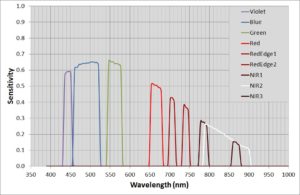
MAIA is the multispectral camera that permits the simultaneous acquisition of high resolution images at various wavelenght intervals in VIS/NIR electromagnetic spectrum regions. It is designed to be employed on board the UAV systems or on board aircrafts, and it finds several applications on board terrestrial rovers too, for precision agriculture, classification of crops, classification of materials on soil, environmental monitoring, dumps monitoring. MAIA S2 is the only multispectral camera equipped with the same wavelenght intervals of the European Spatial Agency’s Sentinel-2™ satellite.
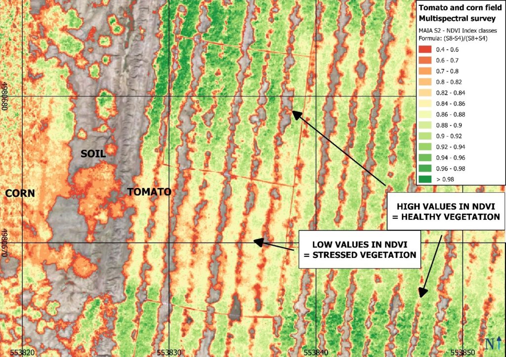
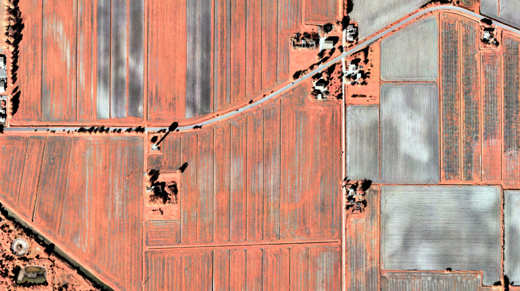
Now, you can compare free satellite data with high-resolution maps obtained through a multispectral survey conducted with MAIA S2, the proper instrument for your multispectral survey.
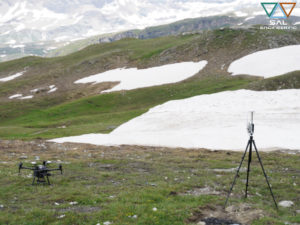
In recent years, several agronomic research or remote sensing institutes have been evaluating the potential of the data provided by Sentinel missions through direct comparison in the field with high resolution optical sensors, and using UAVs for a closer flight. They evaluate the potential of Sentinel-2 data for retrieving winter wheat LAI, leaf chlorophyll content (LCC) and canopy chlorophyll content (CCC). In coordination with destructive and non-destructive ground measurements, they acquire multispectral data from MAIA, measuring key Sentinel-2 spectral bands (443 to 865 nm). Check for example this paper.
MAIA S2 is entirely developed in Italy by SAL Engineering, Eoptis and Fondazione Bruno Kessler.
If you participate in a research project that correlates multispectral satellite data with agronomic data acquired in the field, if you need a higher geometric resolution for your multispectral orthophotos, if you deal with water quality and want to monitor spills in waters, contact us and we will provide the multispectral survey service according to your needs.